Introduction
Makalidurga is a special trek that has a railroad station as its base, unlike any other day hikes in the Bangalore area. Although the Muthuraya Swamy temple serves as the starting point, the two-kilometer journey there from the railway station is thrilling.
According to legend, Makalidurga’s name is derived from two different places. First of all, Makalidurga Trek takes its name from the woody climber “Makali Beru” or Makali Root, whose juice is used to make a health beverage. Juice is a component of some medications because it helps to purify the blood.
Second, Makalidurga got its name because Makaliraya, a “Palegar” or ruler, used the fort as his granary in the late 1800s.
Due to the legend and history surrounding Makalidurga, it is thought that Markandeya Rishi performed penance here.
Many people have changed control of Makalidurga. The fort was first held by the emperors of the Vijayanagara Empire. The Nayakas, however, took control of the fort as a result of their decline. Later, during his reign over the Doddaballapur region in the 1600s, Shahaji Bhosle, the father of Chhatrapati Shivaji, was in charge of the fort.
Makalidurga is conveniently located near roads and railroads and is only 15 kilometres from Doddaballapur and about 60 kilometres from Bangalore. For those looking for a quick weekend getaway as well as more experienced hikers, it is a year-round trek.
What To Be Wary Of
1. A singular experience strolling next to train tracks
A trek rarely begins next to a railroad track, but Makalidurga checks that box. To get to the trailhead, you have to walk along the railroad tracks, which is an interesting experience.
2. A view of Gundamagere Lake, which has a shape similar to that of South America.
The Gundamagere lake resembles the shape of the continent of South America. The highlight of this trek is without a doubt the view of the lake as you ascend to the summit.
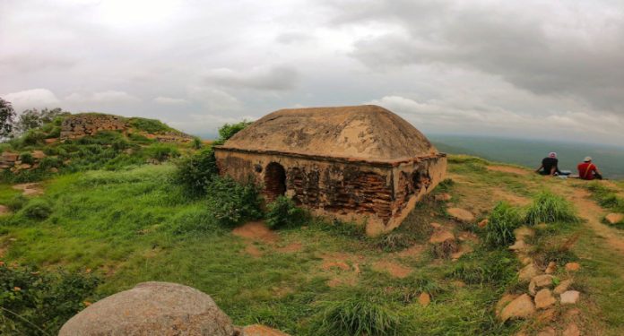
3. The hilltop ancient fortification is in ruins.
The fort at the summit transports you to a time when the fort was bustling with activity and allows you to visualise its opulence in earlier centuries.
4. The Makali Malleshwara Temple
Devotees still climb all the way to the top to worship in the Makali Malleshwara temple, where the idol is still visible. For a fort that is in disrepair, this is an unusual sight.
Details of the Trail
There are two methods for dealing with Makalidurga. One is to start from the Muthuraya Swamy Temple by walking from the Makalidurga Railway Station, and the other is to drive to the parking lot and cross the railroad tracks to get there.
If you start from the train station, the trail can be divided into three sections, and if you start from the temple, it can be divided into two sections.
To reach Muthuraya Swamy temple if you choose the first option, the stretch begins with a flat walk alongside the railway lines. The second section is the one from the temple to Rest Point I, which begins with a gradual ascent over muddy and rocky ground and becomes very steep as you get closer to Rest Point I.
If you are using the second option, this is the first stretch you should perform. To reach the summit, the last section is a moderately steep ascent on granite rock.
-
Muthuraya Swamy Temple to Makalidurga Railway Station
Trekking Distance: 2.2 km
Trek time: 30 minutes
Makalidurga Railway Station’s GPS coordinates are: 13°24’35.32″N 77°30’35.07″E
Muthuraya Swamy Temple’s GPS coordinates are: 13°25’33.51″N 77°30’15.79″E
With Makalidurga hill in your line of sight, begin your trek by making a right turn inside the railway station. It’s a pleasant, flat 2.2-kilometer walk. Always stay on the trail and keep an eye out for passing trains. On the rails, do not tread.
Despite being long, the walk is beautiful and never monotonous. Around you, there are expanses of greenery and rugged boulders, with iron and stones in the middle. The contrast is very stark as you get closer to Makalidurga.
Search for the marking that reads “54/300.” Walking along the railroad tracks comes to an end at this point. In less than 100 metres, keep to your left and seek for a sign from the Forest Department on the left before crossing to the trail.
-
Muthuraya Swamy Temple to Rest Point I
Trekking distance: 1 km
Trek time: 40 minutes
Muthuraya Swamy Temple’s GPS coordinates are: 13°25’33.51″N 77°30’15.79″E
Rest Point I’s GPS coordinates are: 13°25’47.01″N 77°30’03.91″E.
If you’re driving up to the parking area, look for a sizable sign for the Karnataka Forest Department on your left while you’re driving on State Highway 9, and turn left at the sign to enter the dirt road.
Drive till you reach an open area after around 900 metres. This is where you park.
Park your cars here and cross the railroad tracks to the trail’s opposite side, where a sign from the Karnataka Forest Department is posted. On your right, at about 100 metres, is the Muthuraya Swamy Temple. When you come to a fork in the trail, continue straight ahead. A slightly elevated trail will take you to Makalidurga while a trail to your right will take you to Gundamagere Lake. The trail is on your right; take it. Arrows painted on the rocks clearly indicate the path leading to the hill’s summit. To stay on the right path, follow them.
The trail will take you to the summit, so follow it. Don’t forget to take in the surrounding surroundings as you ascend the trail. The area is covered in lush vegetation, especially when it rains. As the ascent steepens, the trail gets more difficult. Using the loose gravel, climb up the rocks and boulders. In this part, there are increased chances of slipping. The trail opens up to a panoramic view of Gundamagere lake when the challenging segment is completed. Take a time to pause and enjoy the view.
You must ascend the last difficult granite rock in a short distance to get to Rest Point I. As you ascend, use the support of the boulders. By doing this, you may be confident there will be enough grip for you to ascend safely. Take a short nap here, eat your refreshments, and take in the stunning surroundings. From Rest Point I, it is possible to see the fort at the summit of the hill.
-
Rest Point I to Makalidurga Summit
Trekking distance: 600 m
Trek Time: 20 minutes
Rest Point I’s GPS coordinates are: 13°25’47.01″N 77°30’03.91″E.
The ascent will come to an end when you reach the fort at the top after following a somewhat uphill track for around 20 minutes.
The historic fort walls that welcome you serve as a reminder of their past. These walls offer a panoramic perspective of the surroundings from above. From the top, it is possible to see two lakes: Gunjur Lake to the East and Gundamagere Lake to the West.
The Makali Malleshwara temple, which is encircled by fort walls at the summit, is the trek’s primary attraction. The historic temple still draws worshippers from neighbouring communities and contains idols of Lord Shiva and Nandi.
Wander around and investigate the fort. A wide range of old artefacts, including crumbling idols on the temple roof and rocks with ancient inscriptions on them, may be discovered.
Close your eyes and take a moment to consider how you got to the top. Take note of the quiet and the natural sounds. Before you begin your trek back to base, ease your sore muscles. You must be especially careful and proceed slowly and steadily through the challenging and steep areas because you will travel the same path to descend. You could fall and suffer serious injuries as a result of slipping.
Ideal Season For Makalidurga Trek
One of the treks that may be completed at any time of year is Makalidurga.
However, because there aren’t many trees along the trail, we advise you to wear a cap in the summer to protect yourself from the sun. You will quickly become fatigued if you don’t wear a hat or cap because of the dehydration brought on by the intense heat. Carry a poncho or raincoat and a rain cover for your backpack during the monsoon season to keep dry when hiking to Makalidurga. However, due to the terrain becoming slick from loose rocks and mud, we advise against trekking during periods of severe rain. This will make the walk less enjoyable for you.
Is the Makalidurga Trek Hard?
Trekking can be tricky but with the right preparation you can easily do it. Level of difficulty can be different for different people. But it’s all about your fitness level.
The Makalidurga trip contains no terrain that may be categorised as particularly challenging. A trekker must, however, constantly plan ahead and be ready for everything.
Checkout Here For More


